

The town of Taree in New South Wales has become the epicentre of the latest weather emergency, with authorities issuing serious flood warnings following torrential rains and flash flooding across the Mid North Coast.
Heavy rainfall over the past 48 hours has pushed the Manning River to dangerous levels, triggering swift water rescues, emergency road closures, and widespread property damage. The Bureau of Meteorology (BoM) has warned that “a lot more flooding is to come” as weather systems continue to lash the region.
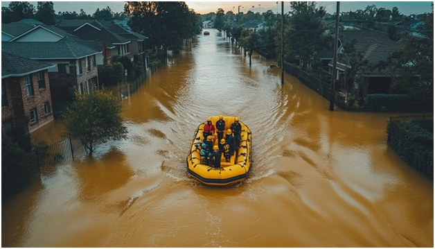
Image 1: Flooded residential street in Taree with emergency vehicles navigating submerged roads.
Source: Stockcake
Taree and Manning Valley on High Alert
Local residents in Taree and surrounding parts of the Manning Valley have been urged to prepare for further evacuations. The Manning River, which flows through the heart of Taree flooding has risen rapidly, breaching minor and moderate flood levels in some areas.
Low-lying zones, particularly near riverbanks and creeks, are at heightened risk as authorities predict continued rainfall through the weekend.
The NSW State Emergency Service (SES) reported responding to over 130 calls for assistance overnight, including multiple rescues from stranded vehicles and flooded homes. Evacuation centres have been set up at Taree Showground and Wingham Memorial Hall to support displaced families.
Road Closures and Transport Chaos
The unfolding Taree flooding crisis has led to major road closures across NSW, particularly in and around Mid North Coast towns.
Transport for NSW has confirmed that sections of the Pacific Highway near Kew and Coopernook have been closed due to water inundation. Drivers are being advised to avoid non-essential travel and follow real-time updates from Live Traffic NSW.
Key routes impacted include:
- Bucketts Way near Krambach
- Oxley Highway between Wauchope and Yarras
- Old Bar Road in Taree, completely submerged in sections
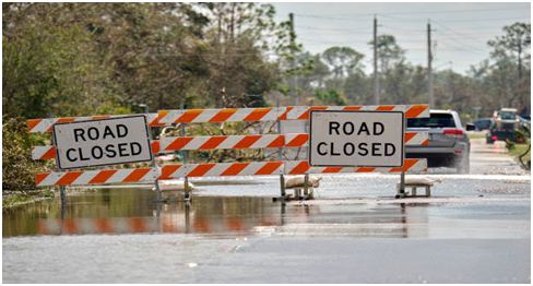
Image 2: Closed section of Pacific Highway under water, with signage and barriers.
Source: iStock
Flash Flooding and BoM Forecasts: “It’s Not Over Yet”
The Bureau of Meteorology (BoM) has continued to issue alerts for flash flooding across NSW, stating that saturated catchments combined with persistent rainfall could trigger further emergencies.
“Mid North Coast communities, including Taree, Wingham, Port Macquarie and Kempsey, should expect further downpours and flash flooding in the coming days,” said a BoM spokesperson.
This follows an official warning issued on May 21, where meteorologists cautioned that the full extent of flooding “hasn’t yet peaked.” The agency also advised farmers and regional residents to monitor river levels closely and heed evacuation orders.
Read more: BoM warns of ‘lots of flooding to come’ – The Guardian
Comparisons to 2021 and Renewed Calls for Flood Infrastructure
While Taree floods 2025 have not yet reached the catastrophic levels of the 2021 event, comparisons are already being made by locals and officials alike.
Taree Mayor Lisa Davis said, “While we’re better prepared today, the increasing frequency of flooding in NSW demands better long-term floodplain planning and infrastructure investment.”
Some residents in Mondrook and Tinonee expressed frustration over repeated property damage and limited upgrades to stormwater systems since the last major flood.
Community Support and Recovery Underway
Local businesses, charities, and emergency responders have mobilised to support affected families. Volunteer groups are assisting with sandbagging efforts while donations of food, blankets, and essential supplies are being coordinated through local council pages and SES social media channels.
A Disaster Recovery Centre is expected to be established in Taree flooding early next week to assist with insurance claims, housing, and financial relief for those impacted.
Image 3: Community volunteers preparing sandbags along the Manning River embankment.
Source: Manning River Times or ABC Mid North Coast (via Facebook)
What’s Next: Monitoring the Skies and the Rivers
With flash flooding in NSW continuing to disrupt daily life across regional areas, all eyes remain on the skies—and the rivers.
BoM has placed large portions of the Mid North Coast and Hunter regions under ongoing flood watch, while inland rivers such as the Macleay and Hastings are also being closely tracked for spillover.
Meanwhile, meteorologists expect a cold front next week to bring further instability to the east coast, raising fears of prolonged flood conditions into early June.
Stay Safe: Key Resources and Alerts
Residents are urged to:
- Monitor official updates via NSW SES and BoM
- Avoid driving through floodwaters under any circumstances
- Keep emergency kits ready in case of evacuation
- Use the NSW Flood Warnings and Road Closures Map for live alerts
Reader’s Outlook: What to Watch as NSW Flooding Unfolds
Communities across the Mid North Coast—including Taree, Wingham, and Old Bar—are facing a critical window in the coming days as river levels and rainfall forecasts continue to evolve. River peaks, forecast rainfall, and infrastructure resilience will collectively determine how much further impact is felt. Emergency services remain on high alert, and residents are urged to take early action where possible.
Authorities and the media continue to provide real-time coverage of flood warnings in NSW, with Taree flooding forming the epicentre of concern. With critical transport corridors already impacted, further NSW road closures could compound delays in aid delivery and recovery.
Key developments to monitor:
- Rainfall projections over the weekend from BoM
- Real-time Manning River flood level readings
- Updates on NSW flash flooding alerts in nearby coastal towns
- New announcements regarding state or federal recovery funding
- Infrastructure assessments in flood-prone suburbs around Taree
Final Word: After the Waters, the Rebuild
As Taree flooding in NSW continues to disrupt lives and livelihoods, the focus will soon shift from emergency response to rebuilding and recovery. For towns like Taree NSW, that recovery means more than just patching up—it demands long-term solutions that reflect the growing challenges of a changing climate.
For now, the message from emergency crews is clear:
Stay vigilant, stay informed, and do not take risks near rising water.